

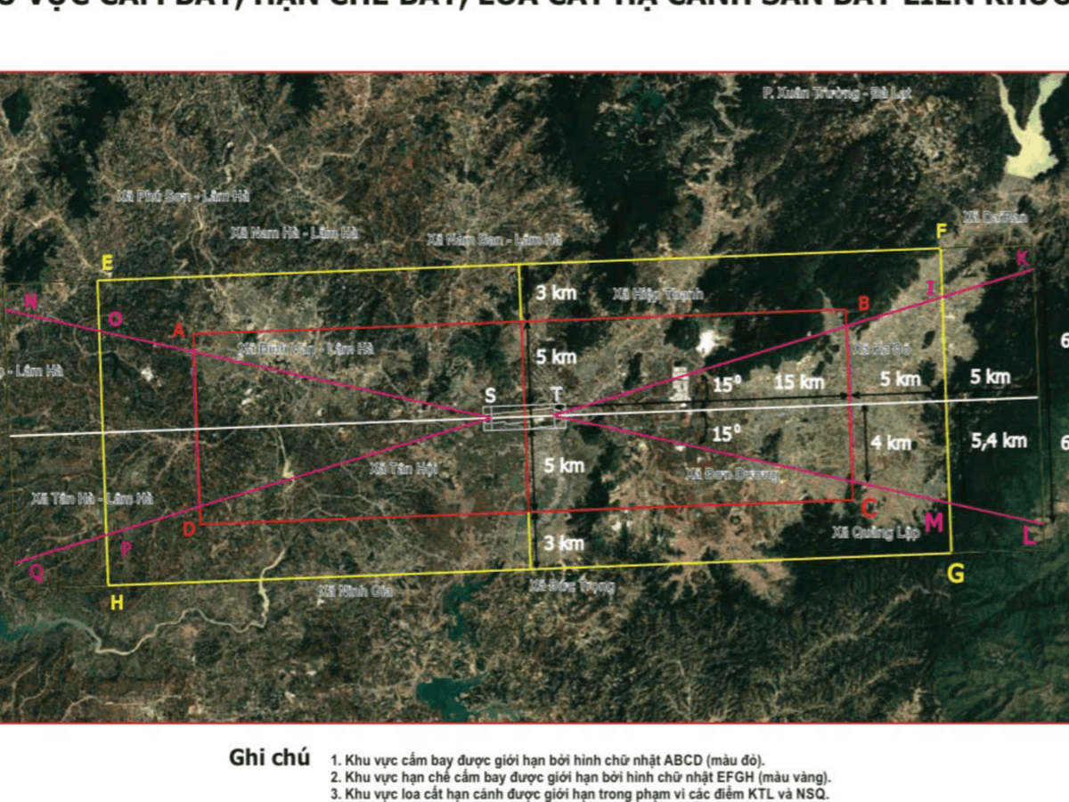
New No‑Drone Zones Near Lien Khuong and Phan Thiet Airports
Lập bản đồ vùng cấm bay drone quanh sân bay Liên Khương và Phan Thiết
Source: Tuoitre
The military command of Lam Dong Province has mapped no‑drone and restricted‑flight zones around Lien Khuong International Airport and Phan Thiet Airport. This information is important for anyone who flies drones for fun, work, or farming.
According to the military command, the zones stretch about 20 km from each end of the runways and 8 km on either side of the flight safety corridors. The maps have been uploaded to Google Earth so the public can see the restricted areas.
Fifteen communes and wards around Lien Khuong Airport are inside the surveyed area, and fourteen communes and wards around Phan Thiet Airport are also covered. The list includes places such as Duc Trong, Hiep Thanh, and Don Duong near Lien Khuong.
The mapping follows several incidents of aviation‑safety violations at Vietnamese airports. Drones are now used locally for filming, tourism, and agriculture, including crop‑spraying near the airports.
The provincial military command warned that flying into the restricted zones or using drones without registration or coordination can pose significant risks to aviation safety. Drone operators should check the Google Earth maps and avoid these areas.
You finished this article
Words from this article
7 recommended words · 0 looked up
Recommended
You looked up
You haven't looked up any word in this article yet.
Practice this article
PracticeRead next
 Latest NewsTravel · B1 · 1 min read
Why Penang Stands Out as the Cheapest Hub for Digital Nomads
Vì sao Penang là điểm đến rẻ nhất cho dân du mục kỹ thuật số
 Latest NewsTechnology · B1 · 1 min read
AI Chip Boom Lifts Cambricon Founder into China’s Top‑10 Richest
Làn sóng chip AI đưa nhà sáng lập Cambricon vào top 10 người giàu nhất Trung Quốc
 Latest NewsTechnology · B1 · 2 min read
How One ID Certification Could Speed Up Your Next Flight
Chứng nhận One ID giúp hành trình bay của bạn nhanh hơn